 Filter: Categories of Wisconsin Historical Images
Filter: FORMAT_DIMENSIONS of 22 x 18 inches
Filter: Categories of Wisconsin Historical Images
Filter: FORMAT_DIMENSIONS of 22 x 18 inches
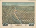
| Date: | 1871 |
|---|---|
| Description: | Darlington, county seat of Lafayette County, was established in the late 1840s, but didn't thrive until the arrival of the railroad in 1856. This view show... |

| Date: | 1875 |
|---|---|
| Description: | Bird's-eye map of Menomonie, with an inset of the County Court House. Spelled Menomonee on map. |

| Date: | 1875 |
|---|---|
| Description: | Bird's-eye map of Platteville. |

| Date: | 1831 |
|---|---|
| Description: | Map of the United States "constructed from the latest authorities," including a statistical table. |
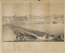
| Date: | 09 22 1862 |
|---|---|
| Description: | The 22nd Regiment Wisconsin Volunteers under the command of Colonel William L. Utley, crossing the pontoon bridge at Cincinnati. |

| Date: | 1997 |
|---|---|
| Description: | A watercolor of a set of archaic Indian deer hunters with their kill. |

| Date: | 1896 |
|---|---|
| Description: | Portraits of the members of the Samuel Harrison Post No. 91 of De Pere, Wisconsin from 1883-1896. |
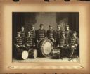
| Date: | 1898 |
|---|---|
| Description: | The ten members of the Drum Corps of the Milwaukee Turners posed in front of a painted backdrop. They are dressed in band uniforms with hats and are holdin... |
If you didn't find the material you searched for, our Library Reference Staff can help.
Call our reference desk at 608-264-6535 or email us at: